



New line · Autonomous systems
You define the mission. The drone flies it.
To us a drone is not a frame and a camera; it is a computer that works in the air. We take any drone platform and write the mission planner, the autonomous flight logic, the vision processing and the ground-control software on top of it. The result: a switchboard inspection, a field survey or a missing-person search is completed without a pilot holding the sticks every second.
The same team that builds the energy system on site also builds the software that watches it — the drone line is that approach taken into the air.
Status
Our own web + mobile control software runs on a Wi-Fi drone (phase 1, October 2026); industrial platform integrations are project-based.
Short films
Two missions, two short films
We turned the story on this page into two short films: a solar plant inspection and a perimeter patrol. The scenes are AI-generated visualisations; the mission screen in between is the real Gökdoğan Flight Control interface.
Solar Plant Inspection
AI visualisationThe drone signals, lifts off from a concrete pad, scans the panel rows one by one, flags a hot spot with its thermal camera and returns to the pad. The engineer follows the mission on the Gökdoğan screen.
Villa Perimeter Patrol
AI visualisationAt dusk two drones lift off together from the garden, follow the high garden wall from inside and outside, check the line with night vision and land back on the same pad.
Play for sound.
Technology layers
Five layers from sensor to ground station
Hardware that measures at the bottom, software that decides at the top. We show plainly which layer we write ourselves and which we take from an existing platform.
- L5
Ground control and dock
Web and mobile ground-control software: mission definition, live telemetry, map, alarms. A drone-in-a-box station (DJI Dock 3 class) charges and handles take-off and landing automatically; we connect the mission plan and the data to the platform.
We write it
- L4
Communications
RF link for telemetry and video; 4G/5G for missions beyond range. If the link drops, the drone switches to a predefined safe behaviour, the mission log stays on board and syncs on return.
We write it
- L3
Mission computer
A second computer on board (NVIDIA Jetson, Raspberry Pi class). It processes the camera feed, detects objects and reroutes in real time, commanding the flight controller over MAVLink / ROS 2. This layer is ours.
We write it
- L2
Flight controller
An open-source flight stack based on PX4 or ArduPilot, or the manufacturer's closed system (DJI). This layer runs the motors, stability and basic modes (take-off, land, return-to-home, hold); we tune it and set the safety thresholds.
Platform / integration
- L1
Sensors and positioning
GPS/GNSS with RTK correction for centimetre accuracy; IMU, barometer, compass. Stereo camera, LiDAR or ultrasonic for obstacle sensing; RGB, thermal (640×512 radiometric) or multispectral camera depending on the mission.
Platform / integration
How it works
Four steps from definition to report
A mission moves from an area drawn on a map to a PDF report without anyone flying.
- 01
Mission definition
You draw the area on the map: the field to survey, the line to inspect, the zone to search. The software computes altitude, overlap and route for the sensor; no-fly zones and the altitude ceiling are applied automatically.
- 02
Autonomous flight
The drone takes off, follows the route and senses and avoids obstacles. When the battery reaches the threshold it marks its position, returns to the dock, recharges and resumes from the same point.
- 03
Detection and decision
Imagery is processed in flight: hot spots, cracks, people, vehicles, diseased crops. When the model finds something the drone moves closer, captures extra frames and records position and measurement.
- 04
Report and action
Findings enter the report geolocated, time-stamped and measured, and are sent by e-mail. Connected to the Energy Monitoring Platform, a drone finding sits on the same screen as the switchboard alarm.
Mission console
The ground station's language: readable telemetry
An example of what you see on screen. Values come from the simulator; in the field the real drone writes in the same place.
Mission 14 · PV array scan · Block BSIMULATIONLIVE
- Altitude (AGL)
- 42 mlimit 120 m
- Ground speed
- 6.8 m/s
- Battery
- 63%RTH at 25%
- Position fix
- RTK Fixed18 satellites
- Mission progress
- 71%14 / 20 lines
- Link
- 4G · 48 ms
Recent events
- Hot spot detected: array B-07, +18 °C10:42
- Obstacle avoided: pole, route shifted 4 m right10:38
- Wind 7 m/s, 80% overlap maintained10:31
Gökdoğan Flight Control
The real screen of our ground-station software
Not a design mock-up: a screenshot of the Gökdoğan Flight Control panel we wrote ourselves. Attitude indicator and compass rose top-left, position map top-right, camera screens below and LED-backlit flight keys at the bottom. Captured in simulator mode; with a real drone connected the same screens fill with live data.
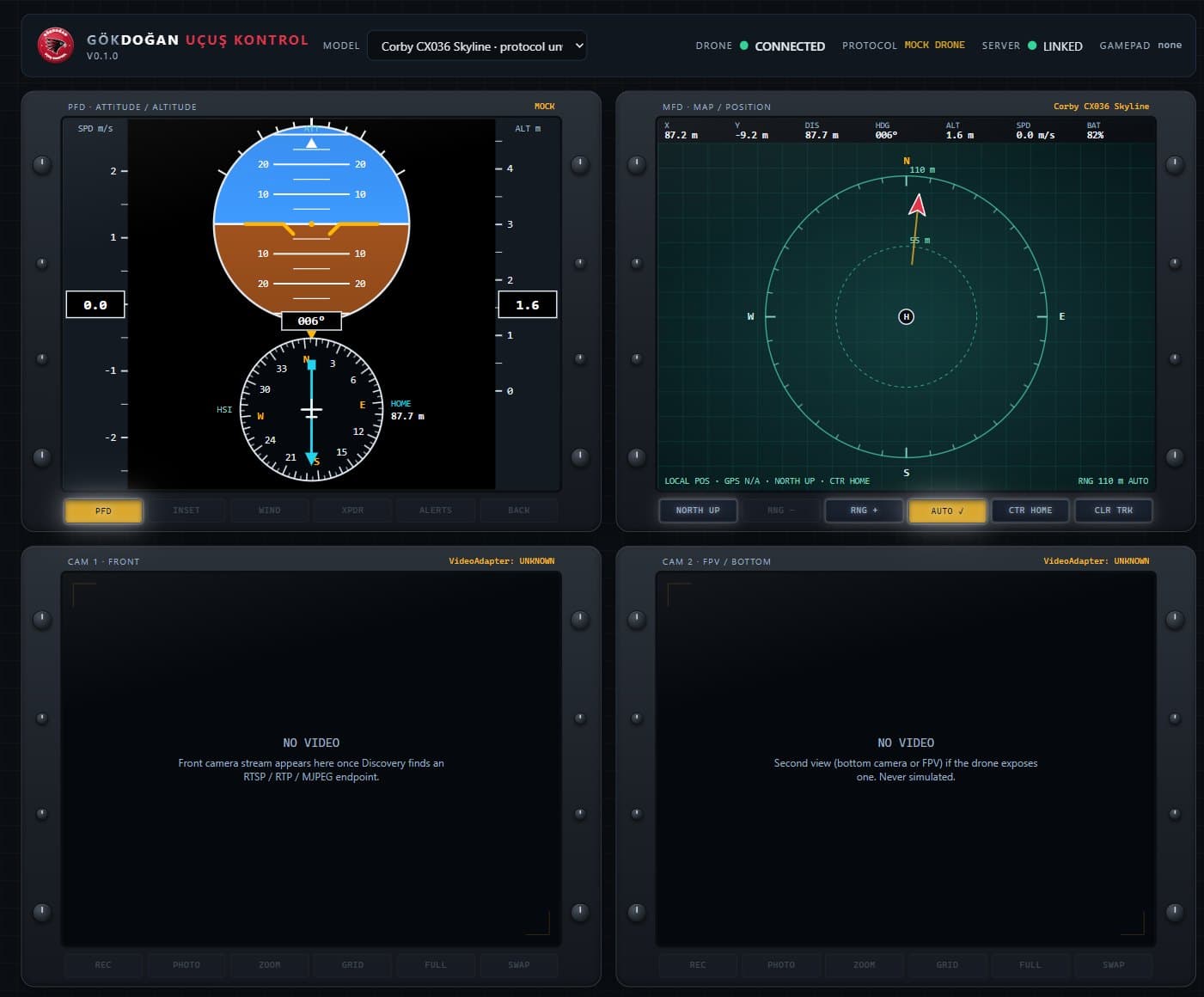
Gökdoğan Flight Control, version 0.1 — web panel, October 2026. Any value the drone does not send is shown as 'N/A'; nothing is invented.
- PFD: attitude ball, speed and altitude tapes, HSI compass with a return-to-home needle
- MFD: position map relative to the take-off point, track trail, range rings
- Keyboard, gamepad and touch control; safety limits are checked before any command leaves
- Multi-model: pick the drone model in the top bar and the software layer switches
Platforms
Every airframe has a job
We choose the platform for the mission; the software layer speaks the same language on all of them. Manufacturer does not matter: DJI, open source or custom-built.
Multirotor
The observer that can hover.
Four- or six-motor airframe. Hovers in place and manoeuvres in tight spaces; the standard for inspection, photography and short-range missions.
- 20–55 min flight
- Thermal + optical payload
- Tight spaces and inside plants
Fixed wing / VTOL
Long lines, wide areas.
Takes off vertically, flies on wings. For pipelines, transmission lines and large-area surveys it offers several times the range of a multirotor.
- Hours in the air
- Tens of kilometres of line
- Mapping and corridor inspection
Agricultural drone
Sprays, spreads, maps.
Heavy platform carrying spray and spreading tanks (DJI Agras class: 40 kg liquid, 50 kg solid). Variable-rate application from a multispectral map.
- Precision spraying
- Variable-rate fertilising
- Terrain following with obstacle sensing
Thermal and inspection
Measures the invisible.
Radiometric thermal camera and high zoom. A hot cell on a PV panel, a warming transformer, a human trace in a night search; every pixel carries a temperature.
- 640×512 radiometric thermal
- Hot-spot alerts
- Night operations
Drone-in-a-box
No pilot, same time every day.
A station installed on site (DJI Dock 3 class) houses the drone, charges it and handles take-off and landing. Mission schedule set remotely; −30 / +50 °C, 10 km radius.
- Scheduled patrols
- Remote triggering
- Vehicle-mounted deployment
Custom-built and indoor
If it doesn't exist, we build it.
A mission-specific airframe on an open-source flight controller: warehouse shelf counting, GPS-denied indoor flight, special sensor payloads. Our own control software started here.
- PX4 / ArduPilot based
- GPS-denied visual positioning
- Custom sensor integration
Fields of use
Same software, six different sites
The mission changes, the method does not: define, fly, detect, report.
Agriculture
Crop-health maps from multispectral scans, water-stress detection, irrigation tracking; variable-rate spraying and fertilising from the map. Only where needed, only as much as needed.
Search and rescue
Night search in rough terrain with a thermal camera and a person-detection model. Heat signatures from 60–90 m up; the model flags a human presence with high confidence and the team goes straight to the coordinate.
Energy and industry
PV arrays, wind-turbine blades, transmission lines, pipelines, substations and stack inspections. Findings share a screen with the switchboard data in the Energy Monitoring Platform.
Defence and security
Scheduled perimeter patrols, intrusion detection, automatic dispatch to an incident. Swarm (multi-drone) mission coordination and software integration with counter-drone detection platforms — with authorised bodies and licensed manufacturers.
Mapping and construction
Orthophotos, digital surface models and volume calculation (stockpiles, excavation); weekly progress comparison on site. Outputs go straight into CAD and GIS.
Disaster and environment
Fire-line tracking, post-flood damage maps, coastal and forest monitoring. When the link drops the mission log stays on board and syncs on return.
What we write
We take the airframe and write its mind
Manufacturers build drones that fly well; what is missing is the software that ties that drone to your mission. We develop six parts.
Mission planner
Draw an area on the map, pick the sensor; route, altitude and overlap are computed. No-fly zones, altitude ceiling and the battery return point are built into the plan from the start.
Autonomous flight logic
Commands to the flight controller over MAVLink / MAVSDK; in-mission rerouting, multi-drone coordination, safe behaviours for lost link and low battery.
Vision processing
Object detection running on board: hot spots, cracks, people, vehicles, diseased crops. The model is trained on imagery from your own site; findings are recorded with position and measurement.
Ground control station
Web and mobile: live video, telemetry, map, alarms; return-to-home in one tap. Several drones and docks on a single screen. Our own software, no third-party account.
Fleet and dock management
Mission schedules for drone-in-a-box stations, battery cycles, maintenance records and flight logs. Flight records kept ready for the regulator.
Data pipeline and integration
Orthophoto and report generation; export of findings to the Energy Monitoring Platform, maintenance software or GIS. The data can stay on your own server.
Numbers from the field
Why autonomous?
These figures are not our measurements; they come from industry sources (linked at the end of the page). We calculate the expected value for your site together.
20 min
drone inspection per wind turbine; 4–8 hours with a rope team
Unmanned Systems Technology
75%
time saved on PV inspection versus manual methods
Oxmaint
60–90 m
altitude from which a thermal camera picks up a human heat signature
DroneXL
54 min
drone-in-a-box flight time, 10 km mission radius, −30 / +50 °C
DJI Dock 3
40 kg
liquid carried per flight by an agricultural drone; 50 kg solid
DJI Agras T50
88,138
registered drones in Türkiye (September 2025)
DGCA / NTV
Regulation
Every flight is bound by DGCA rules
Autonomous does not mean unlicensed. On every project we track class, registration, pilot authorisation and zone permission; the software builds no-fly zones and the altitude ceiling into the plan from the start.
Drone classes
Four classes by maximum take-off weight: İHA-0 (500 g–4 kg), İHA-1 (4–25 kg), İHA-2 (25–150 kg), İHA-3 (over 150 kg). The class sets the registration, pilot authorisation and permission path.
Registration and pilot authorisation
Aircraft over 500 g are registered with the Turkish DGCA (SHGM). Under the new SHT-İHA directive (30 July 2026) pilots hold one of three levels: P0 amateur line-of-sight, P1 commercial line-of-sight, P2 beyond line-of-sight and high-risk operations.
Zones and permissions
No separate permission is needed in green zones; yellow and red zones, flights above 120 m and beyond visual line of sight (BVLOS) require an application. Drone-in-a-box operations fall under BVLOS and are planned together with the project.
The difference
From piloted flight to autonomous mission
With a controller
- A pilot on site for every flight, on the sticks every second
- Photos reviewed by hand afterwards, findings slip through
- The same inspection flown with a different route and quality each time
- Data stays on the card, someone writes the report
With an autonomous mission
- The mission is defined once, the dock flies it at the same time every day
- Findings are detected in flight and recorded with their position
- Same route, same altitude, comparable results
- The report is automatic; the alarm sits beside the switchboard alarm
Honest limits
- We do not manufacture drones. Airframe, motors and flight controller come from DJI or the open-source ecosystem; we write the software on top, the sensor integration and the ground system.
- Our own ground-control software runs today on a Wi-Fi drone (web + mobile, phase 1). Integration with industrial platforms is verified separately on every project; we do not claim to fly every drone.
- In defence and counter-drone work we operate only with authorised bodies and on licensed manufacturers' platforms, on the software and integration side. We do not build radar, jamming or neutralisation hardware.
- Beyond-line-of-sight (BVLOS) and drone-in-a-box operations require DGCA permission; the permission process is part of the project and takes time.
- The figures on this page come from industry sources; the value at your site depends on terrain, weather and platform.
Which mission repeats on your site?
If there is an area to survey, a line to inspect or a perimeter to watch, tell us. Let's choose the platform, the sensor and the permission path together, and draw the first mission plan together.
Describe your missionSources
- 01DJI Dock 3 — drone-in-a-box, Matrice 4D/4TD (UAV Coach)
- 02Drone inspections for wind and solar assets (Unmanned Systems Technology)
- 03Drone inspection of wind turbines and solar farms (Oxmaint)
- 04Thermal and AI in search and rescue (DroneXL)
- 05DJI Agras T50 launch (LOG)
- 06PX4 system architecture — flight controller + companion computer
- 07Number of registered drones in Türkiye (NTV, September 2025)
- 08SHT-İHA: new pilot licence levels (Alomaliye, July 2026)